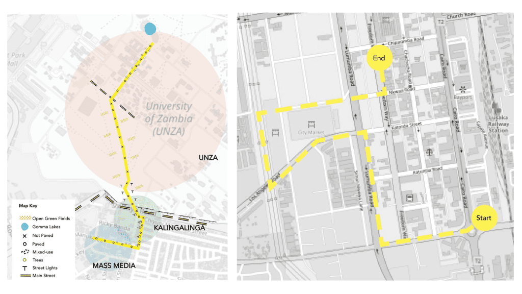
In our first Walking the Un-Walkable walk, we mapped the participating students’ route from the University of Zambia (UNZA) to Lusaka’s higher-density areas (Kalingalinga) and lower-density (Mass Media) neighborhoods. We learned how the simple 15-minute walk from Kalingalinga to UNZA changes into a 90-minute walk in the rainy season when Kalingalinga floods. We were joined by Mr. Maambo B. Haamaundu, Permanent Secretary of Administration of the Ministry of Local Government and Rural Development, who shared his passion for improving drainage systems in Lusaka. The walking group came to the conclusion that the route’s built environment is far too unsupportive of pedestrians. Lacking pedestrian infrastructure (street lights, sidewalks, trash bins, shaded areas, etc.), nighttime safety issues, and a lack of mixed-use development make the route hard to mitigate.
R: The second un-walkable route
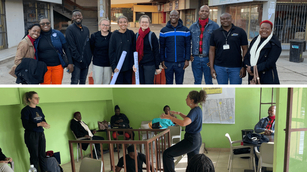
For our second walk, we encouraged participants to focus on access to services and markets along the chosen route, at the suggestion of Muchimba Muvamba, a senior planner at the Ministry of Local Government and Rural Development. We discussed the route during our route co-design workshop, held in April, to involve policymakers in selecting the routes mapped and identifying follow-up opportunities.
To the markets, we go!
This walk aimed to map both buyers’ and sellers’ access to Soweto Market (the biggest market in Lusaka) and City Market. The walk was planned for 7 am so we could witness the early bird sellers walk to open their stands, the small vendors who go to Soweto to buy goods in bulk to then resell in the streets of Lusaka, and your everyday market visitor doing their shopping.
In the first Walking the Un-Walkable Walk, we focused more directly on the activity of walking, mapping the infrastructure and the urbanity of the route. However, a different methodology was used to map this walk, focusing more on the subjectivity of the walking experience. The participants were asked to focus on nothing but the walk itself. “No need to do any mapping!”, we screamed before the walk and asked everyone to focus on the experience.
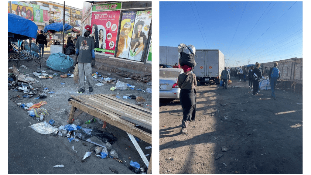
The walk started from Findeco House on Cairo Road (a downtown main street). The group then progressed through Ben Bella Road, Lumumba Road, and Los Angelos Road, passing through Soweto and City Market, ending in a coffee shop on Freedom Way.
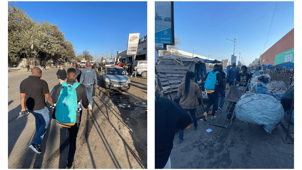
Ben Bella, Lumumba, and Los Angelos Roads are all streets with sidewalks overtaken by street vendors. Only when we turn from Los Angelos Road towards Soweto does the main market area begin. As we started walking early, we experienced the street vendors setting up their stands along Lumumba Road. When we got to Soweto, the vendors there had already set up most of their stalls. We struggled as we navigated the increasingly busy streets of Soweto to City Market and the Bus Station.
After the walk, the group gathered in a coffee shop (featuring some very questionable samosas). The walk was attended by representatives from the Ministry of Local Government and Rural Development (MLGRD), Zambia Institute of Planners (ZIP), Zambia Institute for Policy Analysis and Research (ZIPAR), the Passengers Pedestrian and Cyclist Association of Zambia (PAPECA) and some local researchers. We discussed our experience during the walk, asking participants to reflect on their experience with a few words or sentences. The following points are those most commonly raised by the participants.
Safety
The participants all agreed that they didn’t quite feel safe during the walk. Concerns about “safety” came in many forms. Ms. Foster from PAPECA mentioned that she had to hold tight to her bag as she felt it might be stolen or she might get pickpocketed at any point. John from ZIPAR mentioned that the streets were “not made for walking.” The consensus was that the infrastructure in place doesn’t support a very safe walking experience, as one can easily fall or be hit by a car or other pedestrians, in addition to concerns about pickpockets and crime.
Another safety point raised by participants focused on the danger from “Zam Cabs”. But first, let’s explain what a Zam Cab is. Soweto and City Market are the leading destinations for informal, and sometimes formal, retail sellers to purchase their produce. They are also a great destination for individuals to buy in bulk. Zam Cabs are wheelbarrows explicitly used to transfer the goods from the markets all the way to buses or the car you will need to use to transport the goods to a final destination. Anyone can rent them, and they will take you across the market to any seller destination. But why are Zam Cabs dangerous?
The small space of unpaved pathways in Soweto and next to the market is shared by vendors, buyers, and lots of Zam-Cabs. The Zam-Cab “drivers” push their cabs/wheel barrels very fast across the markets. And without care, you will get hit by one eventually. Fortunately, there is barely any car traffic inside the markets because of the small pathways, limiting the threat to Zam Cabs.
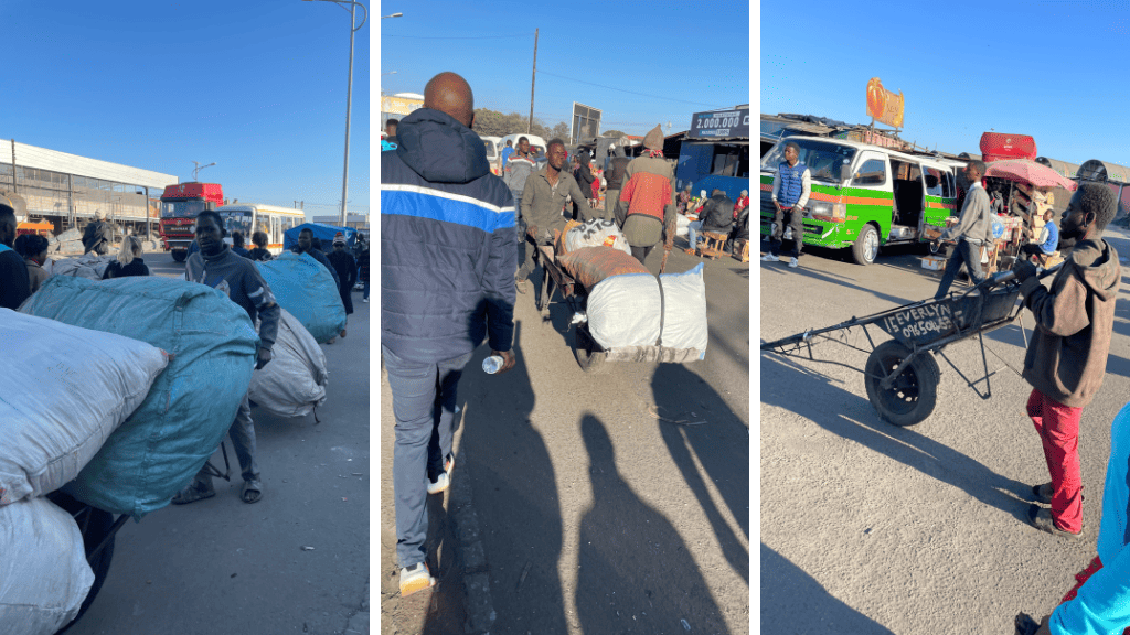
I am happy to report that we have managed to do our walk safely without losing any participant legs to the Zam-Cabs wheels, but I can’t say we didn’t come close to getting hit by one at many points. Zam Cabs, cool as they sound, are actually quite dangerous!
Order
Order was the one point raised by Busiku, President of ZIP and friend of CCI Zambia. Everything is out of order; the sellers, the buyers, the streets. There is a need to find solutions to bring order to those spaces. The group briefly discussed the role of planners and local authorities in bringing that “order” into those spaces. We touched on the city council’s successful and unsuccessful attempts to bring “order” to street markets, including how the New Soweto Market itself is a structure set by the local authorities in an effort to control the street vending that started happening organically. In practice, the structure managed only to attract even more informal street vending around Soweto New Market.
Stress
Many participants used the words “stressful” and “overwhelming” to describe the walk. The sound and smells of the market were disturbing to most. On one side, you are trying to take the experience in and enjoy it; on the other, you are trying to protect yourself from Zam-Cabs. One also needs to protect their bag from being pickpocketed. Shupiwe from PAPECA said that many people sharing such a small place is “hectic” and that trying to navigate those small spaces contributes to the feeling of being overwhelmed and the walk being stressful.
Infrastructure
The co-mapping and discussion that followed the walk also touched on the walking infrastructure. The lack of proper pathways and the sidewalks not being maintained, even in formal spaces made the walk dangerous. The participants failed to identify any streetlights and thought that would make the pathways extremely dangerous at night. The sidewalks on all the streets we walked from town to the markets were overtaken by street vending. The lack of walking infrastructure in a space designed for walking was an interesting point the participants raised.
The co-mapping exercise ended with us promising to do a less “hectic” walk next time, but the discussions brought up many interesting questions:
- Do the markets need order? What does order mean? What will it look like? And who can bring it?
- What does “infrastructure for pedestrians” mean inside a partly formal, partly informal marketplace?
- How can we make the streets safe?
- Is the walk overwhelming for everyone? Where is the line drawn between “hectic” and lively?
- And the most important question is “What to do with Zam-Cabs?”
The walk highlighted the different walking experiences in Lusaka, uncovering the magnitude of people walking from and to the main city markets. How people experience walking differently. “Lively” and “stressful” are both terms that were used to describe the same exact walks. It showcased the Zam-Cabs, as an urban Zambian -somewhat dangerous- mobility innovation. Most importantly, it brought many difficult questions on access to markets, services, and pedestrians.
In the next Walking the Unwalkable outing, we will focus on peri-urban accessibility, highlighting an African urban phenomenon of cities expanding outwards. Stay tuned!
PS: After the walk, I contacted all the participants, and it seemed the questionable samosas didn’t cause serious harm. Hurray to surviving Zam-Cabs and sketchy samosas!